top of page
_cc781905-5cde-3194 -bb3b-136bad5cf58d_ _cc781905 -5cde-3194-bb3b-136bad5cf58d_ _cc781905-5cde-3194- bb3b-136bad5cf58d_ INTERKULTURELLER GARTEN COSWIG_cc781905 -5cde-3194-bb3b-136bad5cf58d_e.V. _cc781905-5cde-3194-bb3b-136bad5 cf58d_ _cc781905-5cde-3194 -bb3b-136bad5cf58d_ _cc781905 -5cde-3194-bb3b-136bad5cf58d_ _cc781905-5cde-3194- bb3b-136bad5cf58d_ _cc781905- 5cde-3194-bb3b-136bad5cf58d_ _cc781905-5cde-3194-bb3b- 136bad5cf58d_
Monthly review July 2023
July was too warm in our region (rank 8 since 1961), too dry and there was plenty of
sunshine (rank 9 since 1961).
Compared to the climate reference period 1961-1990, the month of July was 2.6 degrees too
warm with a mean temperature of 20.6°C. In the long term, the month of July has become
warmer by an average of 2.5 degrees since 1961. After 2010, all July months were
significantly too warm.
The sun shone for a total of 275 hours. This corresponds to a very striking plus of 69 hours
compared to other areas of Germany. In the months of July since 1961, the sunshine
duration in Dresden has increased by an average of 50 hours.
The sum of all individual precipitation measurements reached 52.0 mm in Coswig in July
(54.2 mm in Dresden-Klotzsche). Thus, the past July proved to be too dry in all areas of our
region. The annual precipitation balance so far in 2023 is now minus 4 mm in Coswig in July.
The dryness in deeper soil layers thus continues. In Dresden-Klotzsche, however,
precipitation in the month of July has increased by 25 mm in the long term since 1961.
Weather pattern:
Especially the first half of July was very dry and occasionally hot. The first two decades had
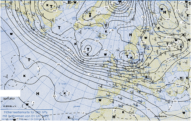
very little precipitation. Only towards the end of July did a westerly weather situation bring
more abundant precipitation (Fig. 1). Nevertheless, the reference value 1961-1990 was not
reached for this month.
In most regions of Germany, however, more precipitation fell in July than the climate
average. Only from the southeastern Harz Mountains to Lusatia, i.e. also in our region, did it
remain significantly drier. In some areas in the rain shadow of the low mountain ranges, only
about 20 to 40 litres of rain per square metre fell.

Fig.1: High-altitude weather map from 31.07.2023. A strong zonal flow at the 500 hPa level is
clearly visible. The jet stream extends from the North American west coast across the North
Atlantic to Central Europe. (Source: Berlin weather map)
Autor: Wilfried Küchler
bottom of page
